


2022-05-15_19h28m37_SityTrail - 3242098 - 2022-05-17-tour-des-gorges-de-lxartuby

verotrail
Gebruiker
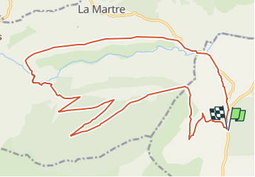

Lengte
14,6 km

Max. hoogte
1309 m

Positief hoogteverschil
422 m
Km-Effort
20 km

Min. hoogte
928 m

Negatief hoogteverschil
431 m
Boucle
Ja
Datum van aanmaak :
2022-05-15 17:28:37.324
Laatste wijziging :
2022-05-15 17:28:35.5

Gratisgps-wandelapplicatie
 SityTrail
IGN / Geografische instituten
SityTrail Plus
De wereld gaat voor u open
Over ons
Tocht van 14,6 km beschikbaar op Provence-Alpes-Côte d'Azur, Var, La Bastide. Deze tocht wordt voorgesteld door verotrail.
Plaatsbepaling
Land:
France
Regio :
Provence-Alpes-Côte d'Azur
Departement/Provincie :
Var
Gemeente :
La Bastide
Locatie:
Unknown
Vertrek:(Dec)
Vertrek:(UTM)
309173 ; 4846861 (32T) N.
Opmerkingen